Building Urban Integrated Land Use Dynamics
BUILD
Context
Preliminary assessment of the problems associated with the urban realm is often displayed in the form of problem tree diagrams, where problems are further bifurcated into the aspect of effects and root-causes based on severity, impact, and interdependence. It is observed that most of the initiatives/programs address the effects of the problems due to their visibility, but only deliver a marginal utility. Initiatives that target the core of the problem are expected to deliver the most sustainable, efficient and smart solutions. With regards to this, the project aims to address some of the predominant challenges associated with the Master Planning approach (i.e., core problem) in the Indian context.
The static master planning approach followed by the Indian cities fails to address the complex challenges posed by rapid urbanization. Today, the cities are not only expanding in size but are also turning to be more complex in terms of their socio-economic, environmental and infrastructural composition. Elite cities globally have adopted a dynamic master planning approach, advocating the power of data for enabling evidence-based planning. Even the Draft National Urban Policy Framework developed by Niti Ayog mentions that Indian cities must have a “NOT Static Master Plan but must consider planning along the lines of evolving ecosystems”. The foremost component of the dynamic master plan is to have a land-use database or base map that is complete and updated in real-time. In this context, the project proposes to develop a ‘Dynamic, Interactive and evidence-based land-use database’.
Problem Statement
The static land use planning approach fails to address the complex challenges posed by rapid urbanization in which cities not only expand in size but are emerging in complex ways with issues ranging from infrastructure availability and a deficit in natural resources. Additionally, sudden impact drivers such as climate change along with local, social and economic tensions further increase the complexity in the urban arena. This makes urban land use planning processes subjective and outdated, often following a top-down approach where community participation is ineffective and happens at a tokenism level.
Due to urbanization, the pressure over the cities is not just limited to changes in urban land cover/land use but also on infrastructure needs to cater to the growing urban population. The rigidness of the traditional tools in the planning process also creates a barrier for the development of the city and these restrictions do not allow authorities to think beyond the limits. The lack of knowledge about the interdependency and intricacies of various infrastructure with the growth of cities also creates a major problem for urban planners and administrators to plan for the cities in an efficient and productive manner. This points out the need to develop a digital tool for indigenous planning and thereby the project aims to lay the foundation stone to a culture of data-driven urban planning in the country’s finest smart cities.
Objective
The objective of the project is to create a dashboard by capturing and integrating multiple datasets from various organizations to produce a dynamic, interactive and evidence-based land use model. Cities periodically collect a wide spectrum of data from day-to-day operations, but the dataset collected is either used only for a specific task/purpose or not used at all. Multiple departments of ULB and parastatal bodies collect data related to built use for collecting service delivery charges and taxes. It is even observed that there is a mismatch in the dataset available with different agencies and there is no interoperability. For example, a particular building is charged electric bills based on commercial use and other state departments charge their service bills based on residential use. Integration of dataset possesses the potential to help departments in eliminating financial leakage and augmenting revenue. The project focuses on integrating the built use data from five services predominantly, namely: building plan approval system, property assessment, trade license, water supply connection and electricity connections. The dataset from the respective system will be integrated through Application Programming Interfaces (API) which will be displayed on an open-source web-based GIS map. The portal will also emphasize fetching crowdsourced data to reduce information mismatch errors. Additionally, citizens can voluntarily request a change of their personal property or can register a complaint mentioning deviation. The information collected from crowdsourcing will be verified physically by the official and post-verification it will be updated on an open-source web-based GIS map.
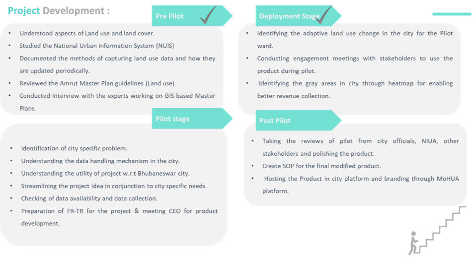
Project Strategy
Pilot City Identification
An assessment was undertaken to finalize the pilot city based on the dataset of the Assessment and Monitoring Platform for Liveable, Inclusive and Future-ready urban India (AMPLIFI) Portal. It is a repository of data procured by various cities defined by different data points. The methodology comprised of the following stages described below was undertaken in all the cities. The first stage comprised of shortlisting the data points relevant to the project such as; the availability of data, parameters such as periodical satellite imagery and land use maps, availability of GIS master plan. Further, based on parameters related to the number of properties based on GIS of multiple numeric values, the nominal data set was evaluated.
The second stage involved the calculation of ‘mapping efficiency weightage' of cities for the shortlisted parameters, based on which the cities were shortlisted. The assessment strategy identified potential cities such as Surat, Bhubaneshwar, Ahmedabad, and Bhopal. The third stage involved extensive secondary research and primary telephonic or video conferencing-based interviews with the respective smart city officials through which, the availability and quality of the dataset on the domain of land use and infrastructure was collected. In this stage, the cities posing a higher Covid-19 threat were discarded even though they had a good dataset. Based on all the above stages, Bhubaneshwar Smart city was shortlisted, which eventually got finalized after the approval of the leadership of Smart Cities Mission (i.e., Shri Kunal Kumar, Mission Director and Joint Secretary, MoHUA and Shri Rahul Kapoor, Director).
Project Development and Implementation

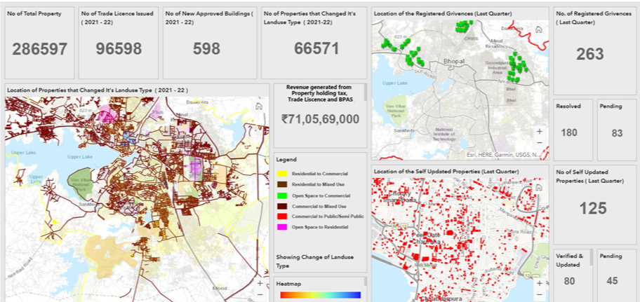
The output results from the overlapping of the datasets are displayed above. It clearly shows the property which has changed the use from either residential or commercial to mixed-use. It points that city is not growing in line with the proposed development plan and there is an urgent need to strictly enforce the development plan that is practically very difficult or either to make the development plan flexible and resilient enough to adapt and address such sudden changes. Additionally, this changes to mixed-use in simple words.
Expected Outcomes
Once developed, the product will have the following characteristics/features:
ULB will get an updated land use base map which is preliminary to any physical planning process/project. This will enable decision-makers to identify grey areas in the city in terms of trade license issued and other revenues that are based on land use, and thereby possess the potential to boost the municipal revenue. Land use change will enable WATCO and other stakeholders to identify plots with changing land use. It will enable ULB’s to identify the rapidly expanding areas within a city for various planning interventions. The tool will be a single platform for data sharing between multiple departments which will enable them to maintain the dataset in a uniform format. Since the dataset is of a granular scale and collected regularly, there is a significant potential for data trading with private entities, research organizations and funding agencies dealing with urban sector projects.
Actual Result
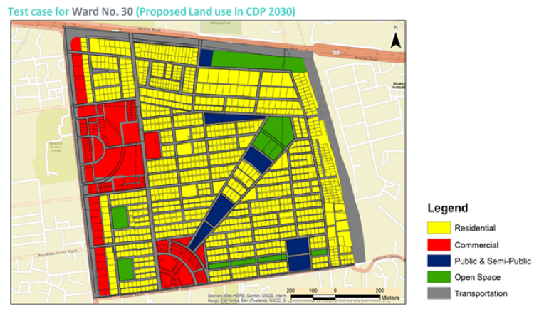
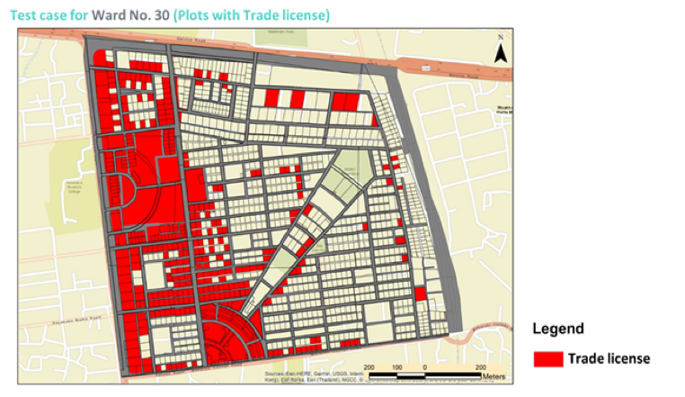
A test case was undertaken by the team for Ward 30 in the Bhubaneswar Smart City. The aim of the test case was to guide the likely outcome to subsequent wards in the city regarding land-use changes and updating that in real-time. Ward number 30 was chosen for the test case after expert and non-expert consultation and it was identified that the ward has undergone a drastic change in the last decade. A portion of the area was ground truth physically by the team to validate the data set that will act as an input to the BUILD Tool. The team found a sizable deviation during the physical survey, bringing into question the dataset envisaged to be used for the project. A demo result for Ward 30 shows that the land use data set from the proposed city development plan and trade license overlap. Further, the land use dataset of BPAS and the datasets that require crowdsourced information are integrated. This tool delivers an opportunity to decision-makers or officials to utilize resources judiciously and effectively.
are deviation, it is an inference from the above picture that predominantly deviations are displayed on the right-hand side. This tool delivers an opportunity to decision-makers or officials to utilize resources judiciously and effectively.
Conclusion
The BUILD tool has meticulously attempted to develop a mechanism wherein the land-use datasets are registered and maintained at plot level in real-time. This tool has initiated a culture of data-driven evidence-based urban planning in the Indian context. It possesses a sizable potential for horizontal (i.e., adapted to different cities) and vertical scale-up (i.e., adding more layers to the proposed tool). The product displays granular plot level land use information which is envisaged to be augmented to ward, zonal and city level and thereby derive holistic information to accredit informed decision making. The tool possesses the potential to value added by integrating the dataset from the system of various service providers such as WATCO (i.e. parastatal agency for providing water) and electricity board. It is envisaged that scaling of the project will offer two-fold benefits as follows; it will deliver an opportunity to practice stimulations and anticipate impacts of various proposed projects to facilitate an informed decision and enable the city to act more sustainably and strategically along with augmenting the inclusion aspect and secondly testing and prototyping can improve a city’s resilience dramatically of lower costs and reduce the possibility of falling in the real world