Help create resilient and greener cities by enabling planned green cover improvements and processes to maintain the green spaces through citizen and community participation.
PRESERVE
Context
Urbanization is occurring at a rapid pace targeting purely economy-centric and anthropocentric development. In such scenarios, environmental concerns usually take a backseat. At present, cities are facing several environmental issues influencing the well-being and livelihood of millions. Urbanization and densification processes have led to a loss of urban green space and biodiversity within cities.
With the increasing frequency and severity of environmental hazards due to climate change, urban design strategies and greening will play an important role in reducing disaster vulnerability, promoting health, and building resilience. To fight this climate change, India has targeted to increase its green cover to 33% of the entire geographical area compared to the present 24%.
Urban green spaces such as trees, gardens, public open spaces, play a very critical role in cooling cities, and also provide safe routes for walking and cycling. This promotes mental and physical well-being, social interaction, and increased social recreation. Since the pandemic, it has become very clear how important these are to the citizens. Along these lines, our project intends to develop a digital tool to contribute towards creating resilient and greener cities by enabling the citizens and communities to contribute in the development of green infrastructure. City planners and local bodies will be bolstered by data driven decision making for improving the green cover of a city
Problem Statement
Due to thinning green cover, loss of biodiversity in urban spaces, low carbon sink, and increasing microclimate, citizen accountability and participation is necessary to develop and maintain better green spaces to improve the quality of life. There is a lack of synergy between various stakeholders of the city which are mainly the citizens and the government. For an urban space to be sustainable the onus of the environment should be shared by all the stakeholders. City planners also need to move towards evidence-based green development which will help in the sustainable and inclusive growth of the city.
Objective
The project aims to build an interactive digital tool to help in creating resilient and greener cities by enabling planned green cover improvements and processes to maintain the green spaces around us through citizen and community participation. With the proposed solution, the vision of the project is (i) To gather data on green cover and streamline it for evidence-based decision making for creating sustainable smart cities. NMT routes, road improvements, native tree plantations can be planned based on the data. (ii) To map green and open spaces for planning better public amenities, and sharing the responsibilities for maintaining these green spaces.
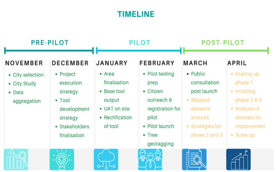
Project Strategy
Pilot City Identification
Smart cities were shortlisted based on certain parameters that were developed through intensive secondary research and a preliminary understanding of the project.
- Data aggregation and analysis: Through existing MIS and Climate Smart Cities data, about 40 cities that were working on green cover and environment were identified.
- Designed indicators: Through secondary research, few indicators such as the cities which conduct tree census, number of public and biodiversity parks, population and area of the city, existing biodiversity projects, the active presence of environmental NGOs, NPOs and research institutions, population, and active citizen participation were shortlisted for further sieving of the cities.
- Stakeholder consultation: Interaction with the city coordinators of the shortlisted cities and relevant stakeholders helped us understand the feasibility of the project. This helped us finalise the pilot city as Kochi. Kochi faces the heat of budding infrastructural development. Therefore it is all the more important to know where the city’s trees are and what can be the scope of future plantations. The total area of open/green space/park in Cochin City is only 0.65 sq km, which is less than 1% of the corporation area. When compared to many other cities in India, the present allocation for open spaces in Cochin City is far lower than what is required.
Project Development and Implementation
Expected Outcomes
- Tree mapping: Data pertaining to the species of the tree, the total number of trees, the proportion of new to old trees available, and the scope for new plantations will be recorded.
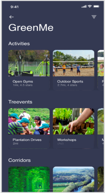
- Identifying green routes: Routes having tree cover as potential NMT route
- Mapping of green/ open spaces with their amenities
- Citizens and stakeholder interaction module: Details on events/activities planned, registration for participants could be updated
- Calculations of carbon sink level
Actual Result
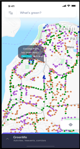
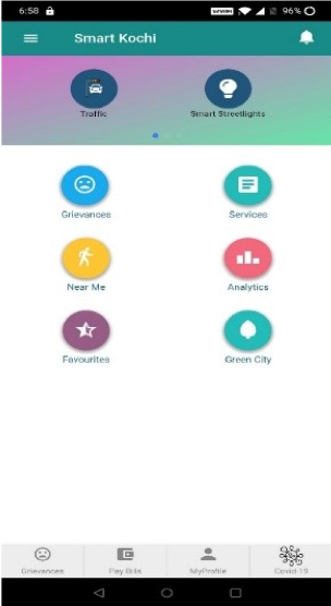
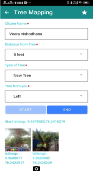
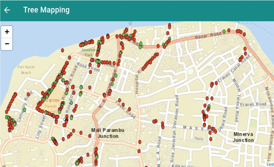
With Kochi city already having a “Smart Kochi” app, the process of tool development was simplified. Phase 1 of the application was designed to geotag trees in the city thereby providing a digitally mapped visualization of the city’s tree and green cover. Once this was ready a pilot testing was conducted at Fort Kochi and Mattancherry areas using trained citizen volunteers for geotagging. Based on the output and citizen suggestions, rectification in the application were done.

The GIS output provides a detailed representation of the number of geo-tagged trees in a particular area along with the details of every individual tree as metadata. The metadata comprises the name of the person who mapped the tree, species of tree, the health of the tree, etc. Based on the output, the following can be identified: 1. Scope of plantations in an area 2. Ratio of native tree species planted 3. Green routes for NMT and green corridor development 4. Trees requiring maintenance
Conclusion
This digital platform would facilitate the holistic way of achieving the main components of the project with the citizens and ULBs working together. Basic city environmental KPIs like planting native tree species, the participation of communities in plantation/maintenance activities and better environmental planning would be achieved through this intervention. This will help to envision the cities’ biodiversity and ecological growth in a sustainable and participative manner.